The Nile Basin Initiative (NBI) is a cooperative arrangement initiated and led by the Nile riparian countries to promote joint development, protection and management of the common Nile Basin water resources. One of the key result areas NBI Secretariat implemented Basin Wide Program focuses on trans-boundary groundwater aquifers. With the financial support of the Global Environment Facility (GEF) and in collaboration with the United Nations Development Program (UNDP), the Nile-SEC will implement its first groundwater study project with the objective of enhancing knowledge and capacity for sustainable use and management of trans-boundary aquifers and aquifers of regional significance in the Nile Basin. This project has five components aiming at strengthening the overall water resources management nationally and basin-wide.
Along the Nile Basin countries, reliance on groundwater is rapidly increasing due to the increased demand over water supply. There is ample evidence that groundwater recharge in the Nile Basin is under threat. This is partly attributed to climate change, high rainfall variability, and land use/land cover changes leading to declining amount of surface/ground water interaction in different areas.
The interaction between groundwater and surface water systems (rivers, wetlands, lakes) has not been adequately considered in most trans-boundary river basin management initiatives, including the Nile Basin. The threats on trans-boundary aquifers are more severe because of lack of common groundwater governance and management mechanisms. Therefore it is of vital importance to build and expand on the understanding of groundwater resources characteristics through detailed investigation, mapping and assessment of the Nile Basin aquifer systems. The Nile Basin Initiative has received funding from Global Environment Facility (GEF) through UNDP to implement a project entitled “Enhancing conjunctive management of surface and groundwater resources in selected transboundary aquifers: Case study for selected shared groundwater bodies in the Nile Basin”. The project aim is to foster the more effective utilization and protection of selected shared aquifers in the selected sub-basin in the Eastern Nile and the Nile Equatorial Lakes region through further improving the understanding of available groundwater resources and demonstrating ‘conjunctive management that optimizes the joint use of surface and groundwater. The project will also contribute to aid the national achievements and reporting of water-related Sustainable Development Goals; and will be supportive to environmental protection whilst enhancing socio-economic development of the basin’s population.
To enhance knowledge and capacity for sustainable use and management of trans-boundary aquifers and aquifers of regional significance in the Nile Basin
Specific Objectives:
- Improve knowledge and understanding of groundwater resources in the Nile Basin;
- Strengthen overall water resources management nationally and basin-wide;
- Respond to climate change impacts through effective risk-reduction adaptation measures - e.g.: conjunctive use and management of surface water and groundwater
- Ensure a healthy ecosystem and strengthened livelihood
Component 1: Furthering knowledge and understanding about availability of groundwater resources in the selected aquifers underlying watersheds in the sub-basins of the Eastern Nile and the Nile Equatorial Lakes.
Component 2: Development of action plans on groundwater resources governance, management, and protection for inclusion in national, sub-basin frameworks: – also including consideration of surface water/groundwater resources conjunctive use
Component 3: Targeted pilot projects to explore conjunctive use of surface and groundwater, and links to biodiversity conservation and climate change adaptation
Component 4: Further strengthening capacity to address groundwater issues at the national and regional levels
Component 5: Communications and awareness raising
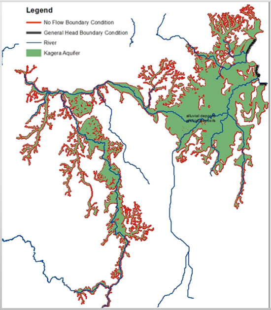
Kagera aquifer is shared among Burundi, Rwanda, Tanzania and Uganda
Conceptual Model
- The conceptual model of the Kagera Aquifer was finalized using the following conditions
- A single layer of alluvium deposits overlaying the Basement complex
- The aquifer is hydraulically connected to the Kagera River and to Lake Victoria in some sections.
Boundary Conditions
- No flow Boundary Conditions beyond the alluvium deposits
- Genearal Head Boundary Conditions in areas of contact with Lake Victoria and Kagera River
Model Data Compilation and Preparation
- Aquifer Geometry
- Top Aquifer Layer
- River Stage Data
- Lake Victoria Water Level Data

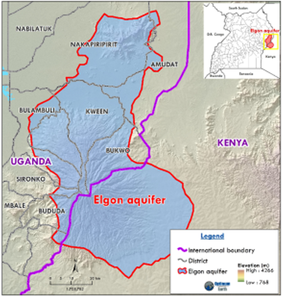
- About 4,900 Square KM, About 85% lying within the Nile Basin
- In Kenya, Lakes Victoria and Turkana basins
- Trans-Nzoia (sub-countries of Endebes and Soroti) and Bungoma (sub-countries of Mt. Elgon, Sirisia, Kimilili and KAbuchai)
- In Uganda, Lakes Kyoga and Trukana basins
- Districts of Manafwa, Bududa, Sironko, Bulambuli, Kapchorwa, Kween and Bukwo
Conceptual model
- Volcanic aquifer is considered to be shared regionally;
- Thickness increasing downslope & hydraulic properties is derived from intrusive igneous & gneissic basement aquifer;
- One-layered groundwater system with boundary conditions defined by geological structures or rivers;
- Recharge largely from the top of mountain & aerially over the lower slopes;
- Discharge from largely springs & rivers/runoff & lesser groundwater abstraction;
- Steady state flow conditions;
Model Data Compilation and Preparation
- Climate (rainfall and PET);
- Drainage (include river level/flow);
- Geology (soils, lithology & structures;
- Land use land cover;
- Groundwater (drilled depth, depth to bedrock, static water level, transmissivity, storativity)
- Groundwater quality
- Monitored groundwater levels
- Regional water demand

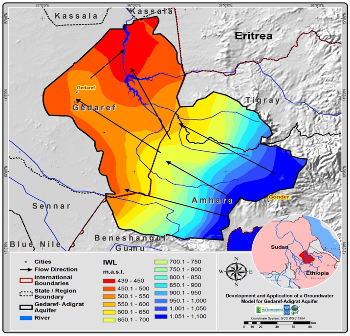
Shared between Ethiopia and Sudan
Conceptual Model
- Single unconfined layer
- Parameter zoning (sandstone, basalt, basement)
- Top and bottom aquifer elevation.
- Inflow and outflow.
- Boundary condition
- Initial heads
Model Data Compilation and Preparation
- Monthly & Annual Recharge (mm)
- Initial Water Levels m.a.m.s.l
- Pumping well distribution

